Atmosphere Structure, Circulation, and Weather
Suggested Readings:
- Ahrens, C. Donald, "Meteorology Today", 6th ed., Brooks/Cole Publishing Co., 1999.
- Samson, P.J., "Blue Skies: College Edition", Brooks/Cole Publishing Co., 1999.
We wish to learn:
- What is the vertical structure of the atmosphere?
- What is the general circulation of the atmosphere?
- What conditions favor thunderstorm formation?
- What conditions favor hurricane formation?
- How might climate change affect changes in frequency or intensity
of storms?
| Introduction
To Global Change I Lecture Notes |
||||
| Structure | General Circulation | Weather |
Self Test | |
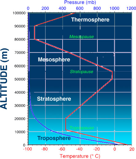 Layers of the atmosphere (click to enlarge) |
1. Structure of the Atmosphere
In large measure, the atmosphere has evolved in response to and controlled by life processes. It continues to change as a consequence of human activities, but at a rate that is far in excess of the rate of previous evolutionary change. The atmosphere controls the climate and ultimately determines the quality of life on Earth. We will begin our discussion with a brief review of the composition and structure of the present-day atmosphere. Then we will discuss the major events in the evolution of the atmosphere that led to its current state. We will discuss some important tools along the way that will prove useful in many settings.
- The word "structure" is used in atmospheric physics
to mean the vertical profile of particular variables of interest
(such as temperature, density, pressure, etc.)
- Atmospheric structure is subdivided into four thermal layers or "-spheres" that are divided by transition regions or "-pauses". The nomenclature used dates back to the 1950's and is based on the measured temperature profile of the atmosphere. Figure 1 illustrates the temperature profile and the names used for the different regions.
As discussed earlier, the ground heats up due to the absorption of visible light from the Sun. The warm ground, in turn, heats the atmosphere via the processes of conduction, convection (turbulence) and infrared radiation. As we move upwards from the ground, we might expect temperature to drop off according to the R-squared law. This happens (more or less) for a while, but the declining thermal structure reverses at the tropopause and increases to a new maximum at the stratopause. In the mesosphere, the temperature drops to the lowest values seen anywhere in the atmosphere. Above the mesosphere, the temperature rises again in the thermosphere. Eventually, the temperature reaches a maximum value at very high altitudes (see Figure above).
2. General Circulation
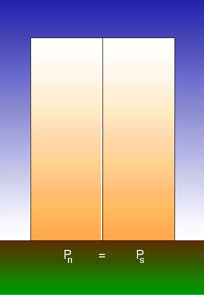 |
| Figure 2. Interactive model of how a direct thermal circulation forms. |
The circulation of the atmosphere is dictated, as a first approximation, by the difference in heating between the tropics and the poles. The difference in surface heating leads differences in pressure above the surface. This in tern leads to air movement from the warmer cell to cooler. The corresponding change in surface pressure resulting from the redistribution of molecules leads to a pressure differential in the opposite direction at the surface. The direct thermal circulation thus created exchanges air between warm and cold regions.
This differential heating leads to the development of a direct thermal circulation known as the Hadley Cell between the tropics and higher latitudes. This circulation cannot extend all the way from the tropics to the poles however as the poleward moving air is turned right (left) in the Northern (Southern) Hemisphere by the Coriolis Force.
The resulting pattern of global winds includes the trade winds from the equator to about 30° latitude. These winds are the result of the air returning in the Hadley cell from 30° to the equator. As it moves it too is turned by the Coriolis Force to its right in the Northern Hemisphere resulting in a persistent wind from the northeast. The point where the trade winds from the two hemispheres meet is known as the Intertropical Convergence Zone (ITCZ).
3. Future Weather
 |
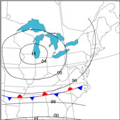
| Figure 3. Current weather information. |
It is pure speculation how the details of weather will change should the Earth as a whole warm. Current expectations are that the greatest warming will happen in the polar regions as the land surface changes from high albedo ice to lower albedo land or ocean. It is further expected that the land surface will warm more than the upper atmosphere. Given these two possibilities we can at least offer some theoretical outcomes regarding cyclogenesis and atmospheric convection.
Cyclogenesis
The development or strengthening of a mid-latitude cyclone is called cyclogenesis (see Figure 3). Some frontal waves form suddenly, grow in size, and develop into huge cyclonic storms. They slowly dissipate with the entire process taking several days to a week to complete. Other frontal waves remain small and never grow into a giant weather-producer. What causes these storms to form, grow and dissipate and how might climate change impact the process?
 |
| Figure 4. Animation of cyclogenesis. |
For mid-latitude cyclones and anticyclones to maintain themselves or intensify, the winds aloft must blow in such a way that zones of converging and diverging air form. Divergence is the process whereby more air is leaving a region than is entering that region. When this happens at the top of the troposphere it removes air molecules from that spot, hence removing mass and consequently lowering the pressure of the atmosphere at the surface.
But as the pressure drops at the surface air will be drawn horizontally into the growing low pressure (convergence) and, in the process this can draw two (or more) air masses toward each other. An air mass is an extremely large body of air whose properties of temperature and humidity are fairly similar in any horizontal direction at any given altitude. Air masses may cover many thousands of square kilometers and carry with them the characteristics of heat and humidity from their source regions.
The converging of air masses at the surface can cause a strengthening of the temperature gradient near the forming surface low pressure. The air in the warmer air mass will be expanded relative to the air in the colder air mass. The greater the difference in temperatures the greater the difference in thermal expansion. As we discussed above for direct thermal circulation a contract in surface temperature will cause winds to occur aloft. In fact, the stronger the temperature gradient the stronger should be the upper level wind. When these winds aloft become focused along a narrow band they are called a jet stream. In principle, the stronger the temperature gradient the stronger will be the jet stream.
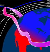 |
| Figure 5. Animation of formation of jet stream. |
This is where the theory comes full cycle because the stronger the jet stream the stronger can be the divergence. Therefore, in a cycle the divergence aloft leads to lowering surface pressure (cyclogenesis) that leads to convergence of air masses at the surface that leads to stronger temperature gradients at the surface (fronts) that leads to differential expansion and stronger pressure gradient aloft that results in stronger jet stream that produces stronger divergence. So, anything that changes the temperature gradient at the surface could influence the rate of cyclogenesis.
While speculative, if we expect the Earth to warm and the polar regions to warm the most this will lead to a diminution in temperature gradient from tropics to poles. Consequently this would suggest a lessening of strength in extratropical cyclones and, possibly, more droughts.
Convection
As was discussed earlier in the semester the temperature in the troposphere is expected to decrease with altitude. In fact the rate at which temperature changes with altitude dictates the likelihood of convection. As air rises (forced upward by thermals, fronts, mountains, etc.) is MUST cool at a rate that is called the adiabatic lapse rate. When the air is not saturated (i.e. the relative humidity is less than 100%) this is called the dry adiabatic lapse rate and this corresponds to a rate of about 9.8°C/km. If the air is saturated raising it will cause condensation to occur releasing heat into the forming cloud. Under these conditions the air would cool at a slower rate, typically around 6°C/km depending on how much moisture is available to be condensed.
The environmental lapse rate, on the other hand, is the actual rate at which temperature decreases with altitude. It can be quite difference from the adiabatic lapse rate because different layers may have gotten heat added or subtracted through absorption or emissions of long-wave radiation or simply because different layers arrive at any location from different regions and carry with them the characteristics from which they came.
Comparing the environmental lapse rate with the adiabatic lapse rates becomes a means to assess the stability of the atmosphere. As a rule of thumb the greater the environmental lapse rate the less stable is the atmosphere. An environmental lapse rate greater than the dry adiabatic lapse rate is called absolutely unstable. a lapse rate less than the moist adiabatic lapse rate (i.e. <6°C/km) is described as absolutely stable. In between the atmosphere is referred to as conditionally unstable. Consequently any process that either heats the surface or cools the upper atmosphere (or both) will make the atmosphere less stable and more prone to convection.
The climate changes expected over North America suggest a warmer surface with less, if any, warming aloft. Given our rules for convection this could result in more thunderstorms and/or convective. This logic suggests the possibility of increased local storminess and, stretching further, short-term flooding.
Conclusions
The projection of weather into the future must be viewed with skepticism as our capabilities to predict such details are limited. Nonetheless we can conjecture mechanisms that could be influenced by general rising temperatures. The reality is that even if these changes do occur it will be difficult to know that they have until years after it begins because the normal variability in weather would make it difficult to sense a trend in cyclogenesis or convection without many multiple years of evidence.
Copyright © Regents of the University of Michigan